Memorable Hikes – Rocky Mountain National Park 2019

Towards the end of April, we spent six days helping our son and his family move into their apartment near Boulder, Colorado. The weather was wonderful…sunny skies with temperatures in the 70’s.

Since we were so close to Rocky Mountain National Park we planned to go into the park after we helped them settle in. It was another beautiful sunny day when we arrived at the park.  

Snow-packed trails.

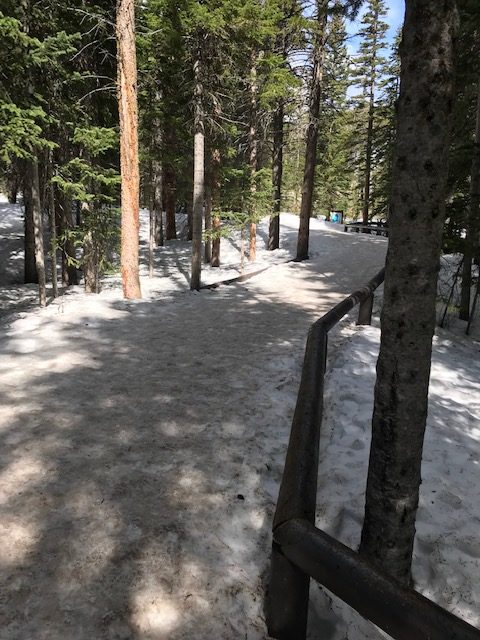
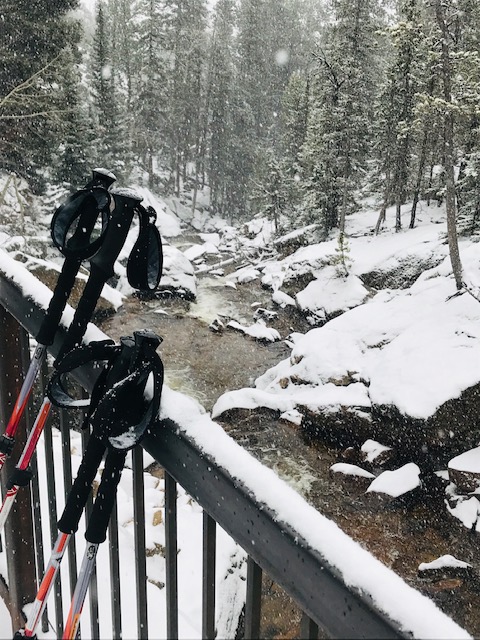
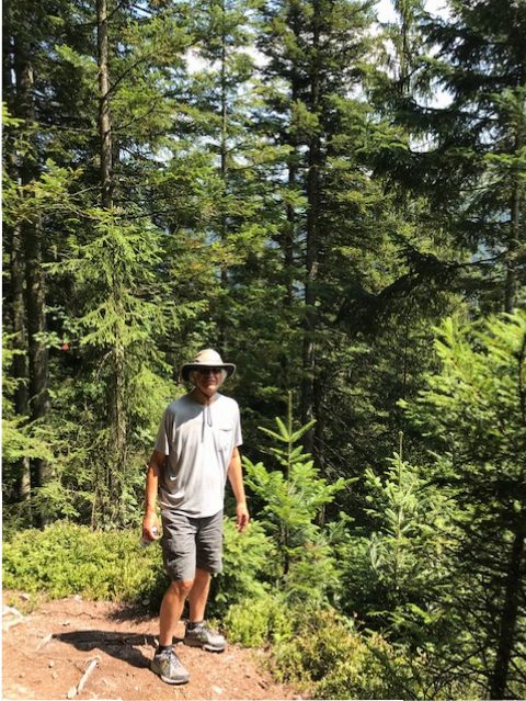
After orienting ourselves, we took a short hike, on snow-packed trails. I’m glad we had our hiking poles because there were several slippery spots.

The next day we decided to hike the Old Fall River Road at a higher elevation (the peak the elevation is 11,796 feet above sea level but we did not hike to the peak.) The Old Fall River Road is closed most of the year…it is only open July through September. The road leads to a side trail down to Chasm Falls which you can access when the Old Fall River Road is closed. When the road is open there is no room for hikers on the narrow hairpin-curved road.

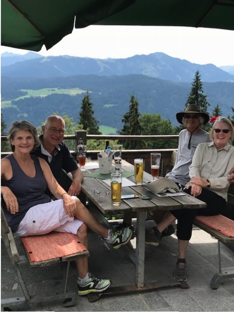
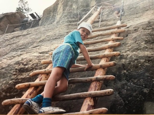
One July, years ago, when we were in the park with our two sons we drove this one-way road up to the peak and across to the other side. It was spectacular scenery.

The beginning of our hike on Old Fall River Road.

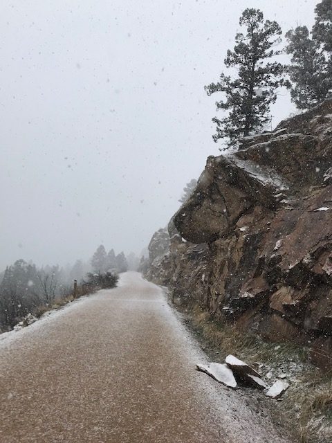
We did bring warm clothes on our trip because we know weather can change anytime in the mountains, and we did need them on this cool and cloudy day. In the morning we bundled up, parked the car, took out our hiking poles and started up the 1.3 mile hike to Chasm Falls.

Gary hiking down the trail to the falls.

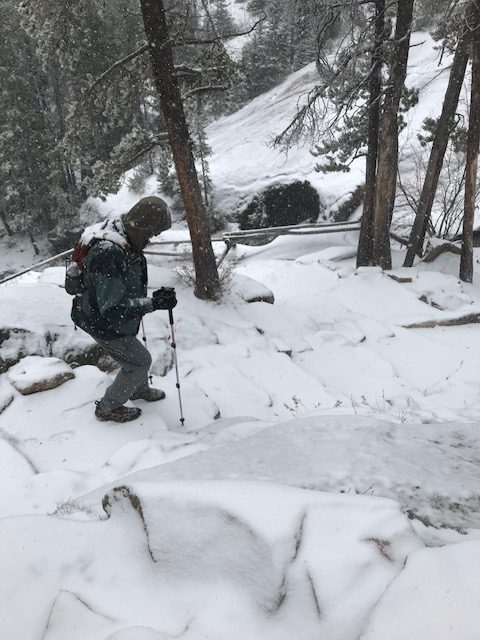
We were the only ones hiking on the road that morning. It was fun to have the wide road all to ourselves. It is an easy hike because of the wide road and because it is hard packed gravel. As we began our ascent, it started to snow…and it snowed all the way up to the falls and continued to snow all the way back down, to our car. It felt like we were in a snow globe. It was beautiful and dazzling and a memorable hike….walking in Rocky Mountain National Park in a snowstorm.

Steps leading down to the platform to view Chasm Falls.
Chasm Falls.

The next day we woke up to eight inches of snow. We did go back into the park for the third day, just to drive around, and we saw a lot of animals this time…maybe because the animals were easier to spot in the snow. We saw a fox, turkeys, three moose, lots of elk, a beautiful blue bird, and several magpies.

Memorable Hikes – Söll, Austria 2018

A fabulous B&B in Söll, Austria

When we checked into our wonderful B&B in the farming community near Söll, Austria we were visiting with the friendly woman at the front desk and asking her about hikes in the area. She suggested hiking to Alpengasthaus Stallhäusl which would take about an hour. That sounded good to us…

Near the beginning of our hike.

She gave us directions and told us the signs to follow so, after lunch, off we went. Fortunately we wore our hats and we brought some water because it was sunny and hot.

Gary

The hike started on the lane behind the B&B. We walked passed a riding stable and a barn where Haflinger horses are bred. We walked past cows with bells clanging around their necks grazing in the fields, and past chickens cackling near their cute coop with flowers blooming in it’s own little flower box. Then we started our ascent…we kept climbing and climbing and climbing, for a hour and 30 minutes, climbing up the mountain.

Haflinger horses.

Cows with their cow bells.

Even this chicken coop had flower boxes!

We did not expect this – the woman forgot to tell us this part – but the vistas were amazing, and we were hiking in the alps! We knew we were on the right trail by the signs.

A view as we were climbing up.

The signs didn’t use distance for a gauge but used the number of minutes to the each destination…35 minutes to here, 5 minutes to there…it’s an interesting way of letting one know where you are.

Looking down on a tractor mowing hay.

Looking down on the town.

Finally we made it to the top after stopping several times along the way to look out at the amazing views (and to catch our breath). We passed beautiful chapel tucked into the hillside (who goes there???)

A beautiful little chapel on the hill.

We were hot and tired and thirsty when we arrived at our destination, the Alpengasthaus Stallhäusl. We sat outside on their sun terrace and ordered something cool to drink and said “Prost” (Cheers!) to toast our accomplishment, and cool down before hiking back to our B&B.

At the top.

We decided to walk back on the road, complete with hairpin turns (that we wanted to roll down to make our journey shorter). Going down is not always so easy…but walking on pavement makes a big difference. It took less time to walk back to the B&B.

It was probably good we didn’t know ahead of time what kind of hike we were embarking on or we may not have chosen to do it…but we’re really glad we did!

Memorable Hikes – Nerstrand-Big Woods State Park

Continuing my series on memorable hikes…

Nerstrand, as we affectionately call the Nerstrand-Big Woods State Park, is one of my favorite local state parks and I think it’s because I go there often. It’s only 20 minutes from our house where we currently live, and we used to drive down to the park from Burnsville where we lived years ago.

Nerstrand-Big Woods State Park, Spring 2018

There is no date for this memorable hike because I do not remember the year. We have gone on numerous hikes in Nerstrand-Big Woods over the years – too many to count or keep track of: wild flower hikes in the spring, long hikes in the summer, fall leaf hikes in the fall, cross-country skiing in the winter.

But the hike I’m writing about for my Memorable Hike series is when our two boys were young. We drove down to the park from Burnsville for the day. Gary had picked up a couple candy bars (which was, and still is, an infrequent treat) to put in his pocket for our hike. While hiking on one of the longer trails at Nerstrand Gary got the idea to go on ahead and place the candy bars near a tree. He wasn’t that far ahead of us to notice he was missing, and he did it quickly. Then when we were all together again, he mentioned to the boys that he thought there was a candy stand somewhere up ahead. The boys were young enough to get excited about that. We continued hiking and, lo and behold, there were candy bars on the ground under a tree. The boys were thrilled. It was silly but was quite fun, and to this day we talk about finding that candy at Nerstrand.

Who knew?

Memorable Hikes – Bay of Fundy, Nova Scotia 2013

Continuing my series on memorable hikes…

Gary and I flew to Nova Scotia in 2013 and rented a car to tour the provinces of Nova Scotia (including the Bay of Fundy)  and Prince Edward Island.

We were hiking around the Bay of Fundy during low tide.  It was amazing to hike far out from shore on the bottom of the Atlantic Ocean, knowing in a couple hours water would rise to cover the entire area once again. And it would be deep waters. The record tide recorded is 53’…it was 43’ the day we were hiking around the sea floor in the Bay of Fundy.A park interpreter making a presentation on Alma Beach, at low tide.

According to Wikipedia: “The Bay of Fundy is a bay between the Canadian provinces of New Brunswick and Nova Scotia, with a small portion touching the state of Maine. It has the highest tidal range in the world.”

I don’t really understand how tides work – I do know they’re connected to the moon’s cycle. I remember when we took a trip to Maine in the 80’s I learned there were two tide cycles each day: two high and two low. I was so surprised. Growing up in the Midwest and not living near the ocean I didn’t know such things. I guess I wasn’t listening in school either. HA

I remember while hiking in the Bay of Fundy, I once again was in awe of God’s amazing creation. When the massive tides recede, the endless mudflats are home to many sea creatures and people love to search for them when the tide is out.

We just enjoyed walking out on the sea floor.

(photo taken from travel brochure)

Memorable Hikes – Washington D.C. 2018

Continuing my series on memorable hikes…

After a beautiful Easter morning service that included the singing of Christ the Lord is Risen Today and hearing the Hallelujah Chorus at a church we were visiting in the D.C. area, we decided to take the train to the National Mall and walk around.

The metro system in Washington D.C. is user friendly and we hopped on the train, along with our host for the weekend, and “people watched” for thirty minutes while we enjoyed the train ride to the National Mall.

The Washington Monument.

As soon as we stepped out of the metro station we saw the Washington monument standing tall. There were lots of people everywhere…and this was April…I can’t imagine the crowds during summer. We turned and looked behind us, to the East, and saw the U.S. Capitol from a distance, and then started our hike walking west toward the Washington Monument.

It was wonderful to see the cherry trees in bloom.

The day was cool but the cherry trees were in bloom and it was beautiful. We walked from memorial to memorial, beginning at the Washington Monument (built in 1848). I have been up in the Washington Monument on a prior visit, but it is currently closed for renovation until 2019. We glanced at the White House to the north as we passed it, then walked through the WW II Memorial (dedicated in 2004) on our way to the Vietnam Veterans Memorial (dedicated in 1982), and a Vietnam Women’s Memorial, a sculpture dedicated in 1993 for the women who served in the Vietnam war.

Next we stopped at the Lincoln Memorial (dedicated in 1922) which is a favorite of mine, and for many I believe.

A classic view of the Lincoln Memorial from one end of the Reflecting Pool.

The statue of President Lincoln.

Next we walked to the Korean War Veterans Memorial (dedicated in 1995) and then to the Martin Luther King Jr. Memorial.

The Martin Luther King Jr. Memorial is a fairly new memorial dedicated in 2011, and this was the first time I saw it and it immediately became a favorite for me.  The Stone of Hope is a granite sculpture out of which the carving of Dr. King emerges. The memorial covers four acres and is located on the Tidal Basin. The walls surrounding the statue are etched with several different quotes from Dr. King Jr. such as:

“Darkness cannot drive out darkness; only light can do that. Hate cannot drive out hate; only love can do that.”

The statue of Martin Luther King Jr.

At this point we were on a trajectory to see the Jefferson Memorial (dedicated in 1943) which took us past the Franklin Delano Roosevelt Memorial (dedicated in 1997), also new to me.

A view of the Thomas Jefferson Memorial across the Tidal Basin.

The King, Roosevelt and Jefferson memorials are all on the Tidal Basin, off the Potomac River, surrounded by blooming cherry trees.


The cherry trees along the Tidal Basin were given as a gift of friendship to the People of the United States from the People of Japan in 1912.

When we started out we had no idea we would hike a total of six miles that afternoon, but it was fun to see these truly amazing memorials. There are interesting stories behind each one.

They are continually adding new memorials and museums in this area. For instance, they are planning a Dwight D. Eisenhower Memorial, under construction at this time, and we visited the newly opened Museum of the Bible which was very interesting.

Washington D.C. is a very unique place to visit and a fun place to hike around, and I am grateful we had the opportunity to do so in the cherry tree blooming season.

Click here to view a good map of the National Mall.

Memorable Hikes – Lutsen, Minnesota 2017

Continuing my series on memorable hikes…

Oberg Lake

The Oberg Trail, near Lutsen, Minnesota ascends about a quarter mile and then levels out to a 1.8 mile loop around the top of this “Minnesota mountain”. The trail has eight scenic overlooks in all directions…several looking out onto the big lake, Lake Superior, and a few overlooks facing the inland forest and a beautiful small inland lake called Oberg Lake. We’ve hiked this trail many, many times over the years…it’s an easy trail and a nice length, close to our rented cabin and a wonderful way to see spectacular vistas of Lake Superior. Some years we get to see the trees in their beautiful autumn array of color. In 2017 we saw an ample start on the fall colors. When the sky is blue it makes the colors more vibrant. This year the fall colors were emerging but the sky was clouded over. It’s still a wonderful sight and a place I love to be!

From Oberg Trail, September 2017.

Last fall our trek up Oberg Mountain we hiked the trail with our son and his wife and our five-month-old granddaughter. It was her first hike on the north shore. She wore a darling moose outfit in honor of the occasion. We didn’t see any moose but she drew attention from the hikers we passed along the trail. It’s funny how babies and dogs often provoke comments from strangers.

She seemed to enjoy the hike, and so did we.

Memorable Hikes – Chincoteague, Virginia 2018

Continuing my series on memorable hikes…

While in the Williamsburg area with our friends, we decided to take a day trip to the Eastern Shore of Virginia. To get there we had do drive through underwater tunnels and over bridges with the Chesapeake Bay on one side and the Atlantic Ocean on the other side.

At the southern tip of the peninsula we stopped at the visitor’s center and learned  in the northern part is where the ‘famous’ wild ponies roam. (The difference between horses and ponies is the height. Any horse that stands less than 14 hands is considered a pony and the average height of a Chincoteague Pony is between 12 and 13 hands.)

I asked how likely it would be to see the wild ponies if we drove over an hour to get to the Wildlife Refuge…the assistant said it was likely. So we took off for Chincoteague.

The Chincoteague ponies started roaming the Chincotegue Island around 1750. Evidence seems to indicate the ponies survived a Spanish galleon shipwreck in 1749. The ponies have been there ever since. The refuge retains a permit to let 150 ponies graze on the refuge so they have to decrease the herd once a year. Annually, in late July, thousands of people gather to watch the ponies swim cross the Assateaque Channel and then the ponies are auctioned off.

After we arrived at the refuge,  we were directed to a paved trail. Along the trail we stopped and talked with an older gentleman who told us he came to the park twice a day, with his binoculars, to look for the ponies. He described two bands (small groups of ponies) in this area. Riptide, was a brown male with a blonde mane and his band was near-by. Maverick, the lead male of a different band, was farther away at this time.

We continued walking but didn’t see any ponies. We came to an “unofficial trail” heading into the woods towards the ocean so we decided to follow it. Once we came to the ocean we talked with a couple who had just seen ponies and they told us which direction to try. We walked along the beach. It was low tide, so there was a wide swath to walk on (with a few obstacles to climb over.)

This turned out to be quite an adventure but we persisted and continued walking until finally we saw movement in the trees, inland along the shore. We spotted one pony, and then another, and another until there were about fifteen. And we identified Riptide grazing in the grass. The ponies were beautiful.

After taking several pictures and watching the wild and wonderful creatures, we started hiking back. On our return trip the tide was rising but our beach swath was still passable. We darted into the woods where we thought we had exited a couple hours ago and finally found the original paved trail and walked back to our car.

It was a exciting and adventurous hike, searching and finding the Chincoteague  ponies in the wild.


Memorable Hikes – Mesa Verde National Park, Colorado 1992

Continuing my Friday series on memorable hikes…

Our family camping trip out west took us to several national parks in 1992. Each park is unique and so much fun to visit and explore. We are so grateful for those who went before us to preserve such wonderful lands.

Cliff Palace, Mesa Verde’s largest cliff dwellingNPS Photo

At Mesa Verde National Park we took a hike to see the cliff dwellings, for which the park is known. Mesa Verde is unique because the park preserves the ancient cliff dwellings of the Ancestral Puebloans. When we were there in 1992 the park called the people Anasazi Indians, but when recently looking up information on the park I discovered they no longer use that term, and the correct name is Ancestral Puebloans.

View of Cliff Palace from aboveNPS Photo

The website reads the park “offers a spectacular look into the lives of the Ancestral Pueblo people who made it their home for over 700 years, from AD 600 to 1300. Today the park protects nearly 5,000 known archeological sites, including 600 cliff dwellings. These sites are some of the most notable and best preserved in the United States.”

Long HouseNPS Photo

The website also gives permission to copy photos from their site as long credit is given to the NPS. “They (the photos) may be used for private, public, or press use. Please credit “NPS Photo.”

We went on a ranger led hike through the cliff dwellings. I remember the ranger’s warning that one had to be able to climb ladder steps and fit through small spaces in order to participate in the hike. It was fun to see the cliff dwellings up close and learn about the fascinating life style of the people who had lived there years ago.

Memorable Hikes – Tent Rocks Nat’l Monument, NM 2017

Continuing my Friday series of memorable hikes…

Kasha-Katuwe Tent Rocks National Monument is located between Albuquerque and Santa Fe, New Mexico. Kasha-Katuwe means “white cliffs” in the Pueblo language. I didn’t know the difference between a national monument and a national park so I looked it up and this is the answer I found:

“To laypeople, the distinction between lands designated as national parks and national monuments can appear finite. The primary difference lies in the reason for preserving the land: National parks are protected due to their scenic, inspirational, education, and recreational value. National monuments have objects of historical, cultural, and/or scientific interest, so their content is quite varied.”

In Tent Rocks National Monument, volcanic rock and ash have formed unusual slot canyons and tent-shape rocks that make up the landscape of this very unique park.

There is a 1.2 mile trail through a slot canyon up to a lookout point and we hiked it one day last fall. The slots through this canyon trail were sometimes very tight, unlike the slot canyon in The Narrows in Zion National Park. The Tent Rocks trail was interesting because of all the distinctive, smooth formations and conical-shaped rocks. 
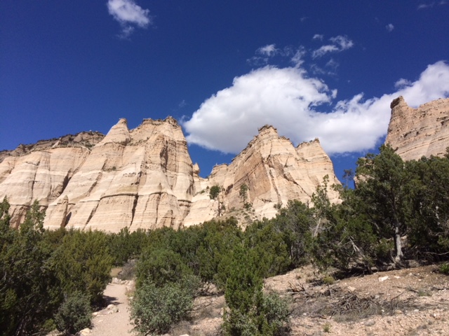
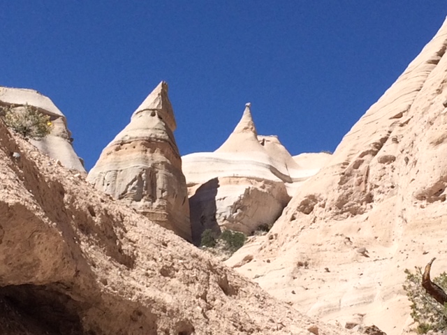
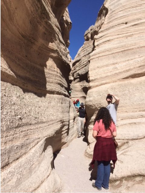
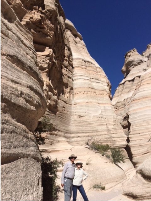
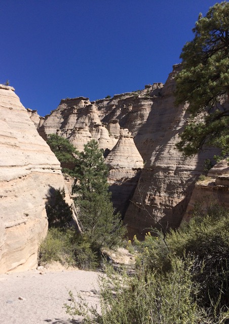
The vistas at the top were great and at the bottom we hiked another mile along the base of these rock formations. It was a fun hike. I had never heard of this park until we planned our trip to New Mexico, but what a wonderful find!

I always enjoy discovering and exploring new places. There are so many in this world…

Memorable Hikes – Cape Town, South Africa 2015

Continuing my Friday series on memorable hikes…

Table Mountain in Cape Town, South Africa

After spending Christmas and starting the New Year (2015) with our son and his family in Mozambique, my husband and I flew to Cape Town, South Africa. It was great to see another country on the African continent. Cape Town is a more progressive city and we were excited to see it and the surrounding area, including the Cape of Good Hope and Cape Point, at the southern most tip of Africa.

Table Mountain is in the center of Cape Town and is visible from anywhere in the city.  It’s flat top makes it looks like a table, hence the name. We decided to hike to the top of Table Mountain.

Getting closer to the top…deceiving photo though – you cannot see the people in it.

It was going to be another beautiful, sunny day in Cape Town so we started hiking up the mountain in the morning with much anticipation and energy. The climb soon became difficult: it was steep, rocky, hot and slow going. But we made it to the top and we were glad when we did.

As we were hiking two people stopped to ask me if I had enough water. I did. We are always careful a about carrying enough water with us when we hike. As people passed us up I noticed a lot of them were younger than we were. About two thirds of the way up we stopped to rest under a rock overhang, to stand in shade for a minute because we were so warm. A young man came up to me and asked if I had enough water. I said yes, and then he asked me to hold out my hat…when I did he poured his water into my hat and told me to pour it over my head. I did and it felt so good. I said thank you and he took off and continued on his way and I never saw him again. I was impressed with such a random act of kindness.

A beautiful view of Cape Town off to one side of Table Mountain.

The views at the top were fantastic and we spent a fair amount of time up there. When it was time to head down we took a cable car instead of hiking. The cable car is continually taking folks up to the top of the mountain and back down again. Usually hiking down is harder than hiking up, so I was grateful for the option to ride down the mountain.

From the window of the cable car.

A funny story about the cable car is we happened to be first in line for the next ride down. When we stepped into the cable car we were excited to get a front row view out the window. Once the cable car filled up and started descending, the floor of the cable car started rotating so everyone was able to have a chance to have that front row view. It was surprising, but what a great idea.

A cable car coming down from the top of Table Mountain.

Even though the hike up Table Mountain was a difficult one, we are happy we did it!